TomTom GO Manual
Here you can view all the pages of manual TomTom GO Manual. The TomTom manuals for GPS Receiver are available online for free. You can easily download all the documents as PDF.
Page 11
11


Note: If you choose not to send location information to us, you will no longer receive our
services. This is because services need to send the location of your device to TomTom in order to
receive the traffic information related to where you are. The end date of your subscription
remains the same, even if you do not send this information to us.
Additional information
If you think that your information is not being used for the purpose for which you have provided it
to TomTom, contact us...
Page 12
12 About TomTom services TomTom services give you real-time information about traffic and speed cameras on your route. To get TomTom services on your GO you need to be logged in to a TomTom account. The way you connect your GO to TomTom services depends on your navigation device. A GO can connect in one of the following ways: With a permanent connection directly from your GO. These navigation devices are called Always Connected devices. With a connection via your smartphone. These...
Page 13
13 Depending on your phones Operating System, this network, or PAN, might be called one of the following names: Personal Hotspot Tethering or Bluetooth Tethering Tether or Bluetooth Tether The PAN function is probably already in your phones Operating System, or you can download an app to create a PAN. Note: Some mobile service providers dont allow their users to use a PAN. If your phone doesnt have the PAN function, you should contact your service provider for more information....
Page 14
14


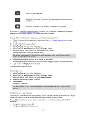
 Bluetooth not connected.

Bluetooth connecting. Your device is trying to automatically connect to
your phone.
 Bluetooth connected. Your device is connected to your phone.
If you want to connect using another phone, you must turn on Personal Area Network (PAN) and
Bluetooth on that phone, then let your device search for the phone.
Connect to TomTom services using a different smartphone
1. Follow the instructions on your device about switching on a Personal Area Network on your...
Page 15
15 Your phones Personal Area Network (PAN), which is also known as Personal Hotspot, Tethering, or Bluetooth Tethering, is switched on. Your data plan with your mobile services provider is active, and you can access the internet on your phone.
Page 16
16


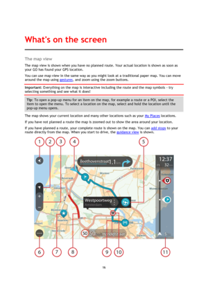
The map view
The map view is shown when you have no planned route. Your actual location is shown as soon as
your GO has found your GPS location.
You can use map view in the same way as you might look at a traditional paper map. You can move
around the map using gestures, and zoom using the zoom buttons.
Important: Everything on the map is interactive including the route and the map symbols - try
selecting something and see what it does!
Tip: To open a pop-up menu for an item on the map,...
Page 17
17


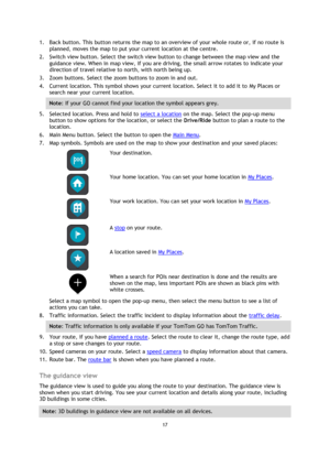
1. Back button. This button returns the map to an overview of your whole route or, if no route is
planned, moves the map to put your current location at the centre.
2. Switch view button. Select the switch view button to change between the map view and the
guidance view. When in map view, if you are driving, the small arrow rotates to indicate your
direction of travel relative to north, with north being up.
3. Zoom buttons. Select the zoom buttons to zoom in and out.
4. Current location....
Page 18
18


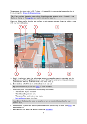
The guidance view is normally in 3D. To show a 2D map with the map moving in your direction of
travel, change the 2D and 3D default settings.
Tip: When you have planned a route and the 3D guidance view is shown, select the switch view
button to change to the map view and use the interactive features.
When your GO starts after sleeping and you have a route planned, you are shown the guidance view
with your current location.

1. Switch view button. Select the switch view button to change...
Page 19
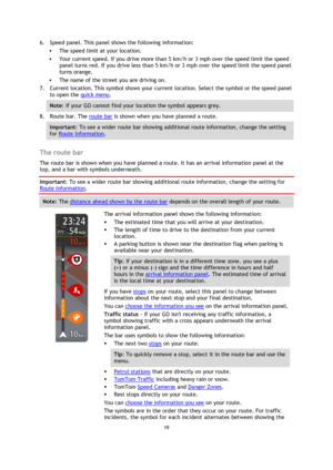
19 6. Speed panel. This panel shows the following information: The speed limit at your location. Your current speed. If you drive more than 5 km/h or 3 mph over the speed limit the speed panel turns red. If you drive less than 5 km/h or 3 mph over the speed limit the speed panel turns orange. The name of the street you are driving on. 7. Current location. This symbol shows your current location. Select the symbol or the speed panel to open the quick menu. Note: If your GO cannot find...
Page 20
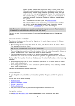
20


type of incident and the delay in minutes. Select a symbol to see more
information about a stop, an incident or a speed camera. If a symbol is
shown on top of another symbol, selecting the symbols zooms in on the
route bar to show each symbol separately. You can then select a symbol.
The total time delay due to traffic jams, weather, and other incidents on
your route, including information provided by IQ Routes, is shown above
the symbols.
For a complete list of incident types, see...
